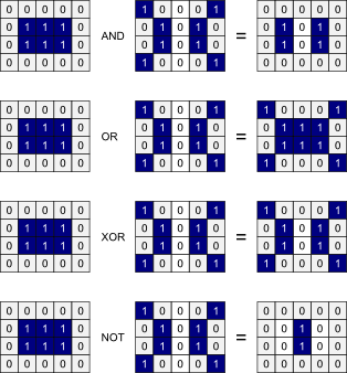
This tool is a Boolean operator, i.e. it works on True or False values. Grid cells for which EITHER input raster has a True value are assigned 1 in the output raster, otherwise grid cells are assigned a value of 0. All non-zero values in the input rasters are considered to be True, whilst all zero-valued grid cells are considered to be False. Grid cells containing NoData values in either of the input rasters will be assigned a NoData value in the output raster.
An example of each of the logical operators (AND, OR, XOR, and NOT) is given below for clarification:
The following is an example of a Python script that uses this tool:
                wd = pluginHost.getWorkingDirectory()

                inputFile1 = wd + "input1.dep"

                inputFile2 = wd + "input2.dep"

                outputFile = wd + "output.dep"

                args = [inputFile1, inputFile2, outputFile]

                pluginHost.runPlugin("OR", args, False)
This is a Groovy script also using this tool:
                def wd = pluginHost.getWorkingDirectory()

                def inputFile1 = wd + "input1.dep"

                def inputFile2 = wd + "input2.dep"

                def outputFile = wd + "output.dep"

                String[] args = [inputFile1, inputFile2, outputFile]

                pluginHost.runPlugin("OR", args, false)